
There is lots to see and do around the Mu Gia Pass. If you’ve been following along in parts 1 & 2, you know just how much effort the US put into trying to interdict this area. Part 3 is the final installment for the Mu Gia Pass. I hope this has given you a glimpse of what went on. I’ll finish talking about those efforts, and then I (and Don Duvall) will go over the places to go and things to do.
In the sixteen months from Nov 68 through Mar 70, there were 30 more aircraft shot downs near Mu Gia; 22 KIA and 2 POW. There were also successful rescues during the period with 26 “saves.” Note that the KIAs include 4 rescue personnel from the Jolly Greens.
This period covers my time at Naked Fanny. It seemed like we were having some kind of Search and Rescue (SAR) nearly every day during dry seasons.
I may not be far off on that. In 1969 there were 93 aircraft shot down over the Trail and another 29 up in Barrel Roll. There were 10-15 others near the DMZ or in Vietnam near the border with Laos. In any case, with our fleet of Sandys (A-1s) and Jolly Greens (HH-3s and HH-53s), SARs were a big part of life at Naked Fanny.
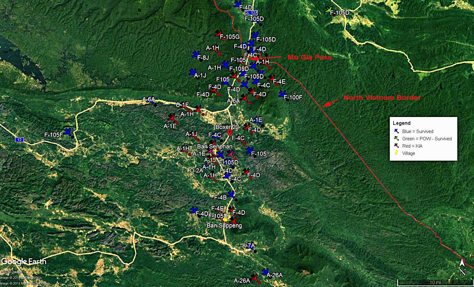
If you look closely at the center of the map you’ll see a red “pin” labled “Boxer 22” in the Phanop Valley. The third day of our Trail ride we’ll be in the Phanop Valley area. This is the site of the largest successful USAF SAR during the Second Indochina War… known as the Boxer 22 SAR. For more about this rescue see the sidebar: “Rescue at Ban Phanop.” (click to open in a new tab)
Following the November bombing halt in North Vietnam, more aircraft were available to strike into Laos. The effort to “shut down” traffic through the Mu Gia area and to silence the guns began to have a significant effect. Of course, the North Vietnamese were determined and resourceful. In 1967 they were already working on a road as an alternate pass… the Ban Karai Pass. By Jan 70, the Ban Karai Pass had twice as much traffic as Mu Gia.
The US had also learned a lot of lessons. A friend of mine, shot down twice flying A-1s, told me they briefed new guys before their first mission… “it’s a bad idea to git into a pissin’ contest with the guns.” He also told me… the second time he was shot down he was… in a pissin’ contest with a gun.”
Anyway… by then the US had probably learned how to avoid most of the AAA in the Mu Gia area. In all of 1970, there were only 7 A/C shot down there; 5 KIAs and 6 survivors.
With the increased availability of aircraft after the North Vietnam bombing halt, Operation “Commando Hunt” began in Nov 68. There were seven Commando Hunts… odd-numbered “hunts” were dry season campaigns and even for the wet seasons. The goal of all seven campaigns was to stop the flow of men and supplies down the HCMT.
Commando Hunt V began for the dry season on 10 Oct 70. The USAF dedicated 27 Arc-Light (B-52) strikes and 125 tactical airstrikes per day (This was for the Mu Gia and two other areas). At first, this worked. One report states that traffic in the Mu Gia area was essentially closed by 13 Oct. But that didn’t last long.

The Air Force was using “target boxes.” Target boxes had been used previously with some success. The rules of engagement would not allow hitting a target just because you saw something of “value” in it. The area had to be free of potential collateral damage. Once approved, the “boxes” were free-fire areas. Target Boxes were 1 km x 2 km areas… sometimes a little larger.
A target box could not have any shrines, temples, national monuments, or places of worship within one kilometer of the box. Also, all huts and villages within one kilometer must be abandoned or “show signs” of enemy military activities. Last, there could be no road watch teams, suspected POW camps, or friendly forces within three kilometers of the box. Pewwww… it was a wonder any bombs could be dropped.
The next two pics show the target box for the Mu Gia Pass area. This box was in the Phanop Valley. The first pic is of the “box” on 8 Oct just before Commando Hunt V began. You can see it was an area that had already been bombed a lot. The second pic was taken on 12 Nov after 30 days of B-52 and tactical pounding. You can see just how badly many of the bombs missed the target box. (Photos taken from the CHECO report “Commando Hunt V, Headquarters 7th Air Force, May 1971. The report was classified “secret” at the time of its publication.)


As amazing as those two pics are… that was only the first 32 days.
Target boxes worked for a while. But again the North Vietnamese determination prevailed. In the case of the Mu Gia Pass region, they built bypasses around the target boxes. When the target boxes changed, they built more bypasses. So it became a game of “cat and mouse” as the NVA kept changing their routes.
Regimented scheduling by US planners allowed the NVA to know the approximate times the bombing would happen. For instance, Arc Light strikes were regimented among take-off times separated by four or more hours. So the NVA knew when those were likely to occur. The same applied to the fighter-bomber attacks. So the traffic remained in hiding areas during likely attack times and moved at others.
One goal of the B-52 strikes, and to some extent all strikes, was to make the roads impassable. The B-52s weren’t good at this. They dropped all their bombs from 40,000 feet in “train.” (That means one after another a few hundred milliseconds apart.) The bombs hit in a string of straight-line impacts. They were lucky if even one of their 66 bombs would hit the twisting and turning roads. (For these strikes the B-52s carried 42 M-117 750-pound and 24 Mk 82 500-pound bombs.)
If the estimate of 30% UXOs is even close to accurate, that would mean every B-52 left behind about 20 unexploded pound bombs per sortie. If you do the math… that’s over 16,000 UXOs per month in the Mu Gia pass area alone… and that doesn’t count the hundreds of tactical strikes per day.
The bombings worked some, but ultimately, these strikes were turning the area into the gravel and dirt pits. The NVA simply used that to repair the roads. After a strike, they would repair the roads and run their convoys until the next strike was due.

Through 1970 and 1971, the US believed the plan of interdiction and attrition was working. Indeed, massive amounts of supplies were no longer getting through the Mu Gia Pass. Or so they thought.
In 1971 there were only three aircraft shot down around Mu Gia. All three were in December. Two of those were warnings of things to come. They were shot down by Surface to Air Missiles… SAMs. One of those two was an F-105G Wild Wiesel specifically there in case of SAMs. The Wild Wiesel was covering B-52 strikes. The second aircraft shot down by a SAM was an F-4E one week later. I don’t have specific information on how the third aircraft, another F-4D, was shot down. Of the six crew members, three were KIA and the other three rescued.
Like some areas up in “Barrel Roll,” the Mu Gia Pass has become a tourist attraction. Guides are available and often necessary to avoid UXO. There are even travel brochures showing stuff to see and do.
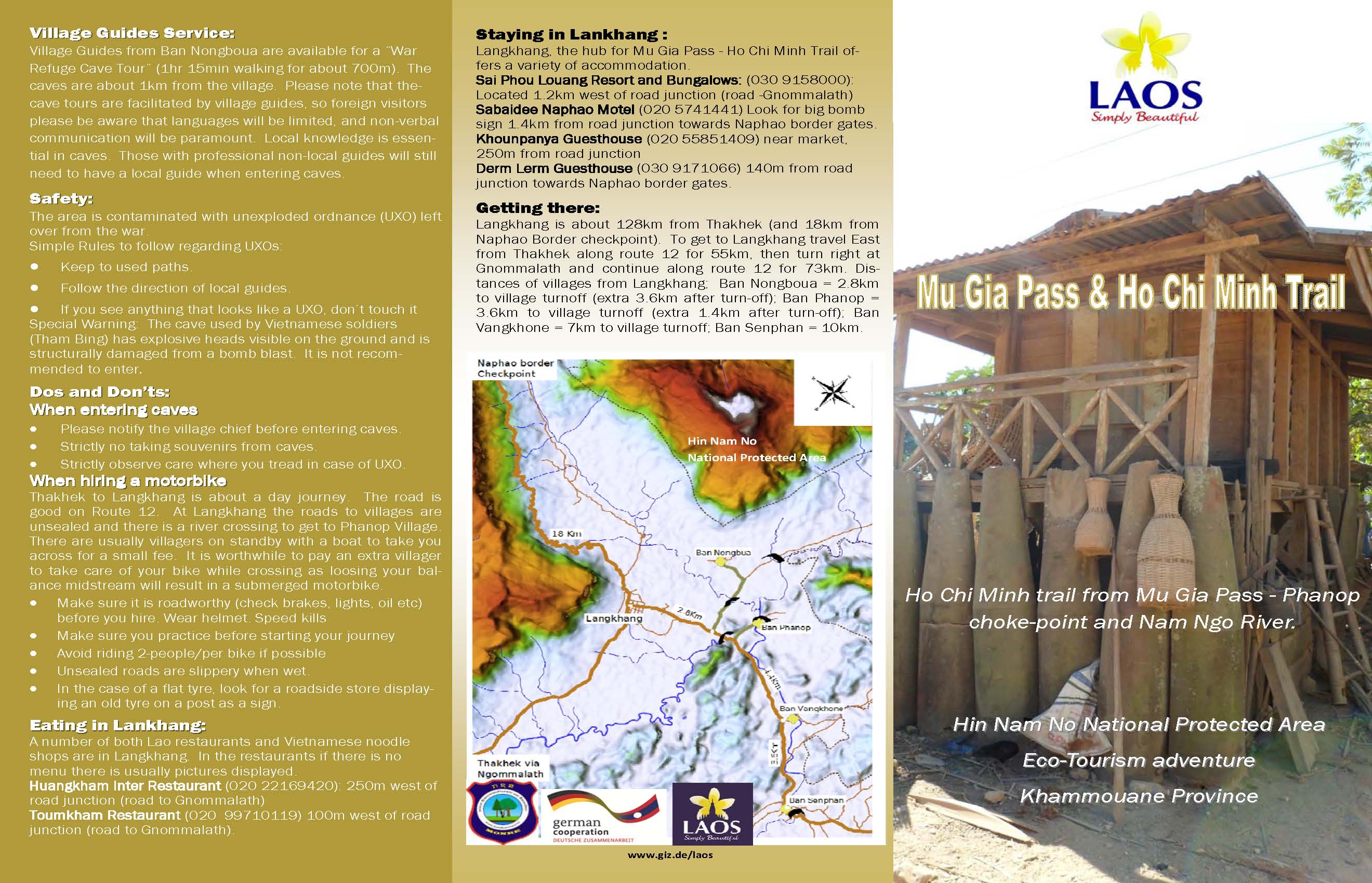

Click on both of the above pics of the tourism brochure if you want to read all the details of some stuff we are likely to explore. Also note that there are warnings about UXOs throughout the paragraphs.
The third day of our “Trail ride” will be in the center of the Mu Gia Pass region. Depending on how our time goes, we will ride through the Phanop Valley and explore all around the area. And of course, riding to the top of Mu Gia pass is a must for me. Again, Don Duval’s description is far better than mine:
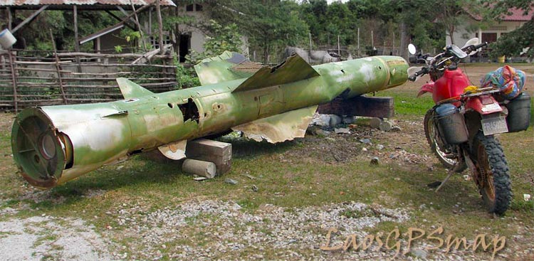
We have some fantastic off-road options if that is what the group likes, or take it easy stopping to check out the remains of Dieter Dengler’s A-1E. Denger was the only POW to escape during the Vietnam war! Another attraction is a Surface to Air Missile along this route.
Dirt route or Paved?
From here we can end up in Langkang, touring along the way. If you still have some punch, it’s a 36 km round trip up the crazy winding road to the Mu Gia Pass and the stunning views. The Vietnamese truckers are thick on this road so it’s a real circus getting up there! And what a contrast to the rest of the trip were very little traffic is observed!
We are now at Ground Zero, and the famous Phanop Valley Choke point. Village visits are a must here. The scene in “Blood Road” interviewing the Old Lady was in one of these villages. There are caves, some war scrap, and lots of cobblestone offshoots were the truck parks, and storage areas were. One of the SA-2 Missiles was found here.
Of course, numerous shoot downs and rescue stories can be cited along this section. The last 2 trips we got held up waiting for Mag to detonate 750 Lb bombs in this area. The amount of UXO is just staggering. Some bridges are now finished along here so we can make good time if need be.
Leaving the area, we’ll head south on the HCMT on our way to the Ban Karai Pass.
Next Up… The Ban Karai Pass.
Is there a lot of unexploded ordnance in these areas?
I’m not the expert here. Perhaps someone who knows more than me can provide a better answer.
The simple answer is yes… there is a lot of UXO. I’m going to do some research and post about it. For now I’ll just say there are ongoing efforts all over Laos to clear UXO. Some farm areas have been cleared, but more stuff is being discovered every day. Some estimates say that at the current rate, it will take 100 years to clear the UXO.
We made an awful lot of gravel for the road crews to repair the road. . Monitored his area almost daily as a PI at Udorn 71-72