
The more I learn about the Mu Gia Pass… and the more I look at images of the area, I can’t figure out why the US couldn’t shut it down. I guess that’s part of why I want to go there… to see for myself.
Before Nov 68, the Laotian side of the Mu Gia pass, indeed all the Ho Chi Minh Trail through Laos, was secondary to the US bombing in North Vietnam. The Ho Chi Minh trail in general and Mu Gia Pass area in Laos received comparatively few dedicated missions. Many attacks in Laos were made on return trips with munitions not used up in North Vietnam.
This makes sense. It was far easier to hit targets in the relatively flat areas in North Vietnam before getting to the pass than it was to hit them after they entered Laos. It would have been even easier to hit the truck depots in the Haiphong harbor and other mass staging areas, but that’s a story for another discussion.
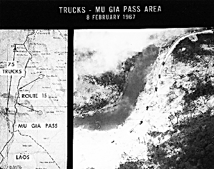
This recon photo and “intel” analysis (above) shows the amount of truck traffic to the Mu Gia pass typical during the dry season in 1967. In the pic there are seven trucks going through a bombed out area. This is likely a section of “The Trail” inside North Vietnam. The “intel” analysis also suggests 75 trucks are in the 10 mile section of Route 15 inside North Vietnam leading to the pass.
Much of the early interdiction effort on the Mu Gia Pass was to block or “cut” the road(s) rather than to destroy trucks going through the pass. Typically, an F-105 strike force was sent in to bomb the roads. Following this, reconnaissance aircraft (such as an RF-101) flew over the area each day to photograph damage to the road. The NVA would go to work repairing the road. When repairs had traffic moving again, F-105s would be “fraged” to strike the road(s) once more. And so it went… “rinse and repeat.”

DAYTON, Ohio — Republic F-105D Thunderchief at the National Museum of the United States Air Force. (U.S. Air Force photo)
Estimates at the time were that the bombing reduced traffic to only 49% of the original volume getting through. What the estimates did not consider was how much foot traffic continued. Also, the North Vietnamese used a shuttle system. A loaded truck would drive to the damaged area. Then porters would carry the cargo across the damaged road section and load it onto another truck waiting on the other side. The first truck would return for more…the second truck with soldiers and supplies would continue on.

Finally, in Apr 68, after 22 aircraft and 16 American lives had already been lost around the Mu Gia Pass, an attempt was made to close it down. Operation Turnpike pounded roads leading into Laos from the pass with B-52 and tactical aircraft. The operation ran from 19 Apr 68 to 24 Jun 68. The objective was to close down the pass through the rainy season. With the main artery roads cut, the truck parks, storage areas, and troop concentrations would become congested, and then they would be bombed.
To some extent, Operation Turnpike worked. During the sixty-five days of the operation, only one aircraft was shot down. However, no one knew for sure just what effect the bombing was having… “The jungle hid the exact results.”
Intelligence specialists, led by General George Keegan (who later became USAF Assistant Chief of Staff for intelligence), said that bombing in comparatively open areas of North Vietnam was more effective. In the Laotian terrain, “Only the availability of a larger commitment of fighters, B-52s, and improved munitions can possibly compensate for the disadvantages of the Laotian terrain.” General Keegan made this comment only a short time before the total bombing halt of North Vietnam on 1 Nov 68.
Once the bombing halt went into effect, the Trail leading to Laos became a super-highway. No, not like an interstate… but compared to what it had been, it was a super-highway. Restricted from missions into North Vietnam, aircraft were then available to start pounding Laos.
On the North Vietnamese side of the pass, they created storage areas, truck parks, fuel depots, and staging areas for the run into Laos. I think pilots attacking the Trail inside Laos must have been able to see that from the air. I wonder how many times the pilots were tempted to “accidently” cross over the border and strike those lucrative targets. I wonder how many actually did. Maybe some readers will comment on this.
One of the reasons I want to go and see it for myself is to try to understand how it was the NVA were so successful. Today, a look on Google Earth makes it look like any “Trail” leading away from the Mu Gia Pass would be completely vulnerable to airstrikes.
Of course, this is all from my computer desk. Since I’ve never been there, I can’t possibly give an accurate description… nor understand the circumstances. That’s why I HAVE TO GO… to see for myself.

It will take a couple of days to get from Vientiane to the Mu Gia Pass. The first day out will be a moderate ride to Na Hin. (Follow along on Google Maps if you like.) Our guide, Don Duval, describes the route this way;
“…great sightseeing along the Karst mountain and limestone forest lookouts there. Keep in mind this is the first day, so we don’t want to push anybody when they are not familiar with the roads and environment. (It’s crazy how many people make silly mistakes first day.)”
Our second day will get us close to the Ho Chi Minh Trail. Actually, we will travel over Route 8; an area of the early HCMT from the Nape Pass on the Laos/Vietnam border. (Beyond the earliest years, the Nape Pass was not used very much, but I don’t really know why. Anyone know?)
We’ll spend the second night at a guest house on top of the Naki Plateau. Here’s Don’s description for this part;
“We have some options via the Lak Sao Route for off-road excursions etc. This day we stay at my friend’s Guesthouse where the crew stayed on the Blood Road Film. It’s on top of the Nakai Plateau, cool weather fantastic scenery, Campfire stay in bungalows enjoy the lake food and beers!”
In case you haven’t seen the earlier posts, Don Duval was a producer, cartographer, and guide for the movie. Click here for the trailer to “Blood Road” (Opens in a new tab.)
Here’s the earlier post about Don Duval, AKA The Midnight Mapper.
Link back to Mu Gia Pass Part 1 (Opens in a new tab)
Thanks for sharing this. I hope Jimmie Butler doesn’t miss this post.
Thanks for the concise report Robert, road 8 was used however the uncut trail accross the Nakai Plateau was rough and difficult, It there is ever ay question if a road or area was used during the war as a Ho Chi Minh trail, Just count the number of Bomb craters along the road! The “Nakai” Plateau would have been a tough mountain to cut a track accross of course it was jungle in those days with a few villages on the Southern side. As is described in Dieter Denglers book Escape from Laos. The Only POW to escape the entire war! This book also describes the journey to the POW camp and of course his eventual miraculous rescue! There were 2 movies made of his experience by Werner Herzog, Rescue Dawn was the Hollywood Version.
We can retrace Dieter Denglers route to the Pow camp, and see the area where he was rescued.
https://en.m.wikipedia.org/wiki/Dieter_Dengler
Was there in 2008 with Mac Thompson, Bill Tilton along with my wife Nancy and I.
Talked with the guards, but they would not let us across to Vietnam. Still, we bought some beer and candy at the outpost where a immigration building was being built.
John Sweet
John I was friends w Mac Thompson wondering if you remember James Michener, who is an ex Huey driver living here in Vientiane now?